Organisation
Redesigning the World Map
Redesigning the World Map: Why Is the World Talking About a New Map?
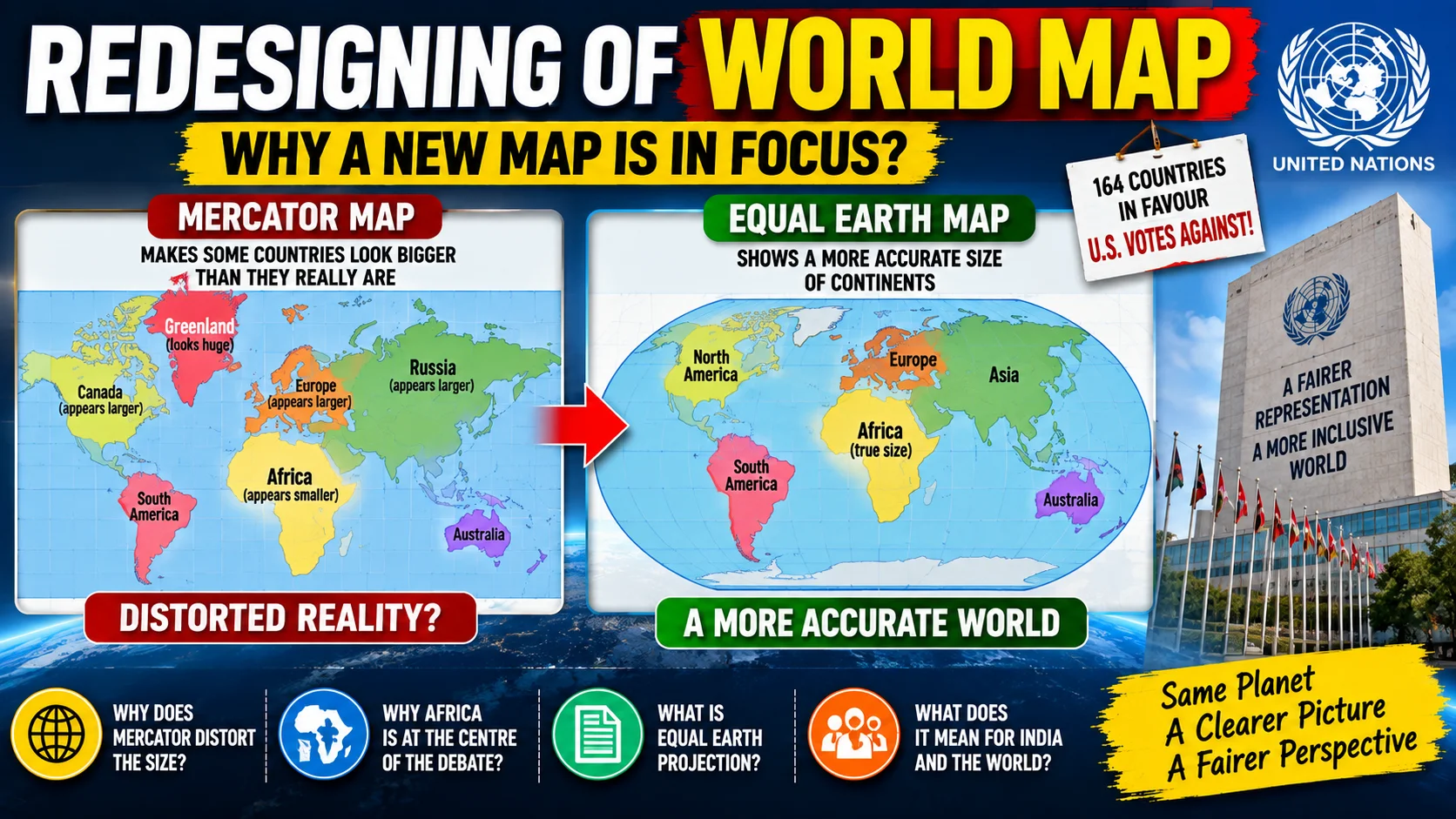
For centuries, the world has been familiar with a particular style of map. It is commonly based on the Mercator projection, created by Gerardus Mercator in the 16th century. However, this map does not show the actual size of countries and continents accurately. Areas close to the poles appear much larger than they really are.
Recently, the debate over a more accurate world map has gained international attention. The United Nations General Assembly has backed a resolution encouraging the use of maps that represent the actual relative size of continents more accurately, particularly through the Equal Earth projection. The resolution was supported by 164 countries, while the United States voted against it. The resolution is not legally binding.
Why Does the Mercator Map Create a Problem?
The Mercator projection was originally developed mainly for navigation. It has an important advantage: it represents directions and angles effectively, which made it useful for sailors.
However, there is a major limitation. As we move towards the North and South Poles, the size of land areas becomes increasingly exaggerated.
For example, Greenland can appear almost comparable in size to Africa on a Mercator map. In reality, Africa is about 14 times larger than Greenland. Similarly, Europe, North America and Russia appear much larger than their actual relative areas.
This does not mean that the Mercator map is “wrong” in every sense. It is a particular mathematical projection designed for a specific purpose. The Earth is spherical, while a map is generally displayed on a flat surface, so some form of distortion is unavoidable.
What Is the Equal Earth Projection?
The Equal Earth projection was developed in 2018 by cartographers Tom Patterson, Bojan Šavrič and Bernhard Jenny.
Its main objective is to represent the relative area of continents more accurately. As a result, Africa appears much closer to its actual size, while regions near the poles appear less exaggerated.
The new approach is therefore more useful for education, geographical understanding and general-purpose world maps, although it does not preserve every feature of the Earth perfectly.
Why Is Africa at the Centre of the Debate?
The campaign for changing the commonly used world map has received strong support from African countries and the African Union.
African leaders and campaigners argue that the way maps represent countries can influence how people understand the importance and scale of different regions. The issue has therefore developed beyond cartography and become connected with historical representation, colonial legacies and global perceptions.
However, supporters are not suggesting that geographical boundaries should be changed. The debate is mainly about how the Earth's surface is visually represented.
What Does This Mean for India?
For India, the discussion is important from an educational and geographical perspective. India lies relatively close to the Equator compared with the polar regions, so understanding different map projections helps students interpret maps more critically.
It also highlights an important geographical concept: no flat map can perfectly represent the three-dimensional Earth. Different projections are designed for different purposes.
Why Is This Important for UPSC?
The topic connects Geography, International Relations, Cartography and Current Affairs.
Civil Services aspirants should understand:
- Mercator Projection
- Equal Earth Projection
- Map projections
- Distortion of area and shape
- Latitude and longitude
- Africa's geographical size
- Role of the United Nations
- Colonial legacy and global perceptions
The most important lesson is that a map is not simply a picture of the Earth. The choice of projection determines how the world is visually represented.
The discussion over redesigning the world map is not about changing countries or international boundaries. It is about creating a more accurate representation of the Earth's land areas.
The UN-backed initiative has brought attention to how geographical knowledge is presented in classrooms, media and digital platforms. At the same time, the Mercator projection will continue to have practical uses, particularly in navigation.
For students preparing for competitive examinations, this issue is a simple but powerful example of how Geography and Current Affairs can intersect with history, technology and international politics.
Grace IAS Academy – Civil Services Preparation
Understanding such contemporary issues with strong conceptual clarity is important for Civil Services preparation. Aspirants searching for Top IAS Coaching in Chandigarh or Best IAS Coaching in Chandigarh can benefit from an approach that connects Current Affairs with the static syllabus.
For UPSC preparation, Top UPSC Coaching in Chandigarh and Best UPSC Coaching in Chandigarh are common searches among aspirants looking for structured guidance, regular revision and analytical preparation.
For State Civil Services aspirants, Top Civil Services Coaching in Chandigarh, Best HCS Coaching in Chandigarh and Top HCS Coaching in Chandigarh are relevant searches for candidates seeking focused preparation.
Similarly, students preparing for Punjab PCS often search for Best PCS Coaching in Chandigarh while looking for integrated Current Affairs, General Studies and test preparation.